Arch Rock is Mackinac Island’s most famous and spectacular limestone formation. A century ago, curious visitors could find two additional arches, also celebrated for their natural beauty and rich traditions. Today, Sanilac Arch exists as a remnant of its former self, while Fairy Arch only remains in artwork, photos, and written accounts. Their stories highlight the importance of preservation and serve as reminders of nature’s continual process of change.
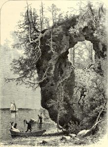
Fairy Arch
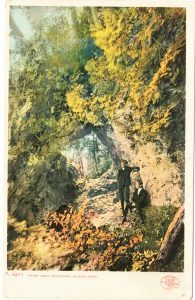
Fairy Arch was first described in 1802 by Dr. Francis LeBarron as one of Mackinac Island’s two “natural arches of the Gothic order.” Over the following decades, a thick undergrowth of young trees blanketed the island landscape, which had been previously cleared for firewood. For most of the 19th century, Mackinac’s eastern shoreline was difficult to explore, covered by huge boulders and thick vegetation.
In 1866, Fort Mackinac surgeon Dr. John R. Bailey rediscovered the 40-foot formation and coined the name Fairy Arch. Despite challenging access, the lovely arch appeared on 19th century maps and in guidebooks. In 1872, Constance Fenimore Woolson wrote, “Fairy Arch is of similar formation to Arched Rock, and lifts from the sands with a grace and beauty that justify the name bestowed upon it.”
In an 1875 guidebook for visitors of the newly created Mackinac National Park, publisher John Disturnell noted Fairy Arch was about ¼ mile from Arch Rock. He wrote:
“A little north and beyond [Robinson’s Folly] a high pinnacle of rude rock crops out from the mountain side, near the base of which is a very picturesque arch, known as the ‘Fairy Arch,’ or Arch of the ‘Giant’s Stairway.’ This spot is rather difficult of access owing to the presence of huge rocks and an entangled forest.”
Fairy Arch became more accessible about 1900, when a boulevard completely encircling Mackinac Island was completed. From the shore, visitors were encouraged to climb huge limestone ledges, like giant steps, to explore this natural wonder. A 1918 guidebook noted, “To visit Mackinac Island and fail to climb the Giant’s Stairway and view this beautiful handiwork of nature, is to miss one of the leading features of the “Fairy Isle.”
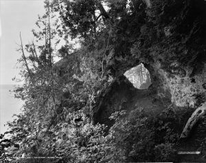
To improve travel around Mackinac Island’s lakeshore, state highway M-185 was completed in 1933. In a misguided erosion control effort, Fairy Arch was destroyed in the late 1940s. Today, this unique formation only remain accessible through artwork, photographs, and written reminisces.

Visitors to The Richard & Jane Manoogian Mackinac Art Museum may enjoy a lovely and somewhat idealized view of Fairy Arch painted in 1874 by landscape artist Henry Chapman Ford. This oil on canvas painting is an example of luminism, a type of landscape painting popular from the 1850s through the 1870s. Click Here for museum hours and information.
The Little Arch
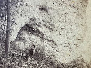
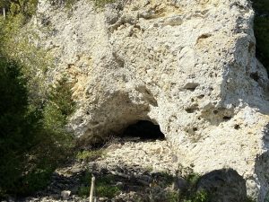
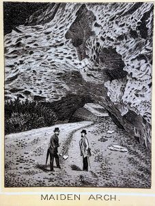
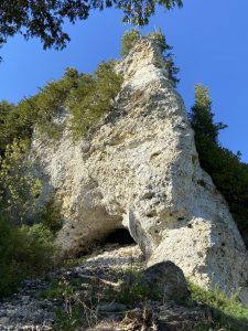
One half of Arch Rock rests on a large pinnacle of Mackinac breccia limestone that towers 130 feet above Lake Huron. Near the base of this cliff is a small, tunnel like arch, which is now nearly filled with rocky debris. Once much larger, this small arch has been known through the years as the Lower Arch, Little Arch, Maiden Arch and Sannillac Arch.
In 1874, photographer James A. Jenney, of Flint, Michigan printed a series of Picturesque – Mackinaw stereoview cards. His view, entitled, “Lower Arch to Natural Bridge” is one of the earliest known photos of this formation. A similar view was published by Mackinac Island photographer Edward P. Foley in 1887, entitled “Maiden Arch, Under Arch Rock.” For many visitors, this smaller formation was easier to explore from the lakeshore rather than risking a steep hillside climb to view Arch Rock from above.
When Mackinac National Park was dissolved in 1895, the island’s arches became part of the newly created Mackinac Island State Park. That year, a visitor named “M.A.” described Maiden Arch in a small volume entitled, Eight Days Out.
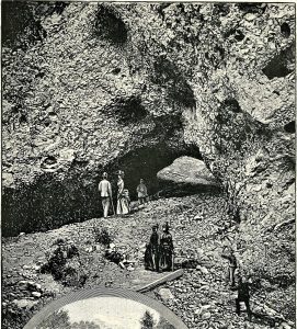
1886 (left) & 1890 (above)
“From [Robertson’s Folly] we followed the beach north to the foot of Arch Rock… There we discovered an interesting arch, which is not on the program, but is more wonderful, and will exist for ages after the renowned arch has crumbled and gone. It is directly under the high cliff, or promenade which extends out into the lake, that tourists walk out upon while viewing the Arch Rock… Two hundred dollars would pay the expense of a winding stairway, down through the principal arch, then under the lower one, and extending to the lake, which would be the most picturesque scene on the island.”
Maiden Arch was renamed Sannillac Arch in 1916, by author Frank O’Brien, in his booklet Names of Places of Interest on Mackinac Island, Michigan. Sannillac, a Wyandot leader, was the subject of an 1831 narrative poem by Henry Whiting. Written in the style of Native American legend, the popular work contained notes by Henry R. Schoolcraft, Indian Agent on Mackinac Island from 1833-1841. According to local lore, this small arch was a gate through which fairy children entered Mackinac Island, while giant fairies entered through the larger portal, Arch Rock. Over the years, its name was shortened to Sanilac Arch.
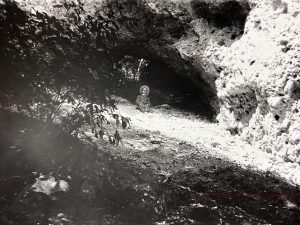
Before 1950, tourist literature encouraged visitors to climb through Sanilac Arch. In 1948, an article in The Island News noted, “Mackinac Island [State Park] does not point it out with an official marker and it can only be reached by scrambling up the bluff. The little limestone rocks crumble underfoot and make ascent a tricky accomplishment. The alpenstock is proper equipment.”
For thousands of years, erosion has naturally carved out the hillside beneath Arch Rock. Today, the space under Sanilac Arch has nearly filled in with small rocks and other debris. Protected behind a fence and stone wall, the little arch may only be enjoyed from a distance to protect this unique formation and preserve visitor safety.
