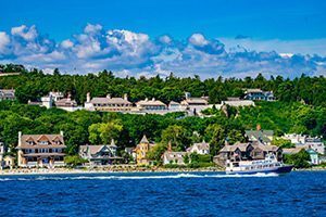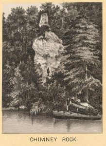
Chimney Rock was once one of Mackinac Island’s most famous geological wonders. A slender sea stack of hardened brecciated limestone, the formation once stood tall along the western shore, rising 131 feet above Lake Huron. In the early 1920s, the base of the formation crumbled causing the spire to topple, and the feature was slowly removed from tourist maps. Over time, confusion arose with nearby Sunset Rock, a popular overlook near the Inn at Stonecliffe. Today, some maps label Sunset Rock as Chimney Rock, although the latter formation is actually a short distance to the north, closer to the shore.
Early Accounts
The earliest description of Chimney Rock was written by Thomas McKenney in 1827. Touring the island on ponies, he wrote, “From [British] landing we rode around the western and southern shores of the island, and saw the chimney rock, which is pretty much like the one at Harper’s ferry of the same name, and stands like that on the side of a hill. It is like that also, a body of stones, which happened to have been supported by resting on one another in the hill, which once embosomed them, but the earth and looser particles having been washed away, these now stand out exposed to the view.”
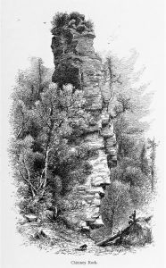
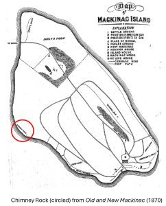
Chimney Rock first appeared on a map in 1870, when James A. Van Fleet included it in Old and New Mackinac. Two years later, a highly exaggerated sketch appeared in the nationally popular series, Picturesque America, or The Land We Live In. Edited by William Cullen Bryant, the two-volume work featured the country’s most spectacular natural and historical attractions. The Mackinac Island section, written by Constance Fenimore Woolson, helped increase awareness of the remote Michigan retreat for a national audience. In 1875, roughly one-half of the island was christened Mackinac National Park, the nation’s second.
For most of the 19th century, the best way to access Chimney Rock was from the water, due to high lake levels and the lack of a pathway along the shore. Dwight H. Kelton, in his 1882 guidebook, Annals of Fort Mackinac, noted “Devil’s Kitchen and Chimney Rock are easier reached by boat.” The fact that both formations were on private property apparently deterred no one, authors and visitors alike.
Early Photographs
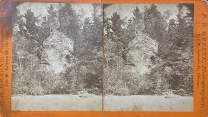
The earliest photos of Chimney Rock were printed as stereoviews. The first view (left), by Plymon B. Greene, was printed as part of a “Views of the National Park” series. Taken between 1875–1882, it shows the base obscured by scrubby vegetation with a very narrow beach in the foreground.
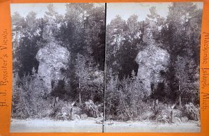
The second view (right) was taken between 1884-1895 by Mackinac Island photographer Henry J. Rossiter. Brush near the base had been cleared away and the waterline remained close to the formation. Comparison reveals a tall tree growing on the rock in Greene’s image was missing by the time Rossiter took his photo. A twisted cedar tree, clinging to bare rock halfway up the formation, appears in both photos. Remarkably, it is still growing today.
Before Collapse
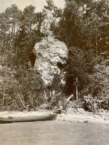
Published in 1899, The Standard Guide: Mackinac Island and Northern Lake Resorts featured photos by H.J. Rossiter. Its authors included Chimney Rock as one of the chief natural objects on the island which “may be seen most expeditiously by employment of the carriage service, which is a feature of the island.”
Rossiter’s photo provides the best view of the formation before it collapsed in the 1920s. This image was taken before the autumn of 1896, when Lake Shore Boulevard (M-185) was completed along Mackinac Island’s western shoreline.
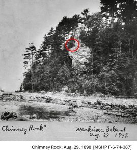
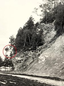
The image at right, taken August 29, 1898, shows Chimney Rock hovering above the recently completed boulevard. The twisted cedar tree, noted above, is highlighted by a red circle.
Reports of Collapse
Chimney Rock enjoyed two decades of celebrity after Lake Shore Boulevard was completed. By the early 1920s, erosion had weathered its limestone base to an alarming state. In 1926, Florence Fuller published a small Map and Guide of Mackinac Island, noting, “About fifty feet of this rock fell recently, crumbling under the weathering of years.”
 A special “Mackinac Bridge Edition” of Sault Ste. Marie’s Evening News also mentioned the collapse. Printed November 1, 1957, it noted, “Although tourists for the past half century have been predicting [Arch Rock’s] collapse and disappearance, the rock is still solid and apparently a permanent fixture. Chimney Rock, a towering limestone pinnacle on the other side of the island created in much the same way, partially collapsed a number of years ago.”
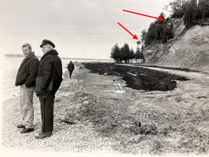
An excellent profile of the collapsed formation was captured in this 1972 photo. The towering spire is shown broken into pieces, highlighted by red arrows.
Enlarged at right, the former middle section, including the crooked cedar tree (circled), had slumped down the slope, nearly to the edge of the road. The formation exists in a similar state today.
Chimney Rock Today
Today, Chimney Rock is easily visible from M-185, along Mackinac Island’s western shore. Located slightly north of Mile Marker 6, the formation lies adjacent to a large cleared hill (which is private property). After its base collapsed, Chimney Rock’s middle section (highlighted by a red rectangle) slumped down the slope, coming to rest in a slightly counterclockwise position.
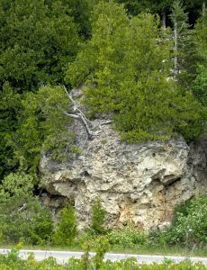
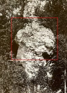
A detailed analysis of Rossiter’s photo provides an excellent point-to-point comparison with current conditions. Note the large “bump” on the left side of the formation with a slim “beaked” feature protruding beneath. Close inspection shows many other holes, seams, nooks and crevices also align. As noted above, the crooked eastern white cedar tree remarkably survived its journey, and is still partially alive today.
To date, Chimney Rock is Mackinac Island’s only known geological wonder to suffer natural collapse. Now forgotten and broken, this feature towered over the Straits of Mackinac for millennia. It deserves a place in the story of this special island, to be remembered by future generations.

